There is a version of Tenerife that you see from the resort pool, from the organised excursion bus, from the beachside sunlounger. It’s pleasant. It’s warm. It’s exactly what it says on the tin.
And then there’s the version you see from behind a steering wheel, on a winding mountain road at 7am, with no tour group behind you, a ravine on your left and the Atlantic on the horizon ahead.
These are not the same island.
Tenerife has some of the finest driving roads in Europe — not in spite of being a small volcanic island, but entirely because of it. The terrain is extreme, varied, and compressed. In the space of 90 minutes you can drive from sea-level resort motorway through pine forest to a 2,000-metre lava field, then down the other side through banana plantations to a black-sand fishing village. No other island this size in the Atlantic does that.
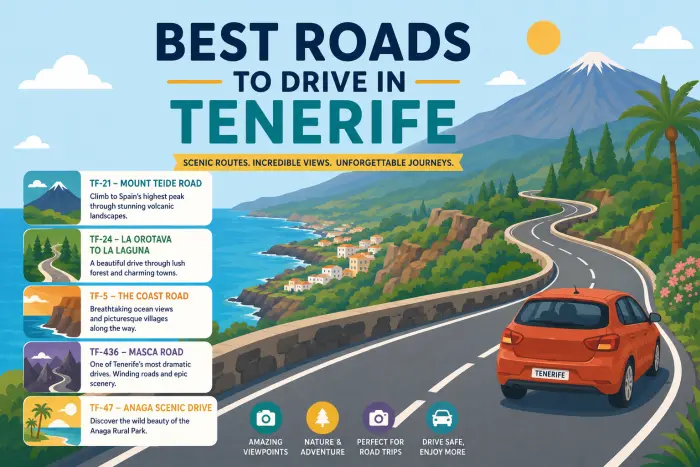
This guide covers the seven best roads and routes in Tenerife — honestly rated for difficulty, with specific advice on timing, which car to take, where to stop, and what nobody else tells you.
🗺️ Quick Reference — All 7 Routes at a Glance
| Route | Road | Difficulty | Best Time | Car Size | Unmissable Stop |
|---|---|---|---|---|---|
| 1. TF-436 — Masca Valley | TF-436 | ⭐⭐⭐⭐ Hard | Before 9am | Small/compact | Mirador de Cherfe |
| 2. TF-21 — Road to Teide | TF-21 | ⭐⭐ Easy-medium | Dawn or late afternoon | Any | Roques de García |
| 3. TF-12 — Anaga Massif | TF-12 + TF-123 | ⭐⭐⭐ Medium | Morning | Compact | Mirador Jardina |
| 4. TF-47 — West Coast | TF-47 | ⭐ Easy | Any | Any | Los Gigantes cliffs |
| 5. TF-38 — Teide West Descent | TF-38 | ⭐⭐⭐ Medium | Morning | Any | Boca Tauce viewpoint |
| 6. North Coast Loop | TF-42 + TF-445 | ⭐⭐ Easy-medium | Morning | Compact | Garachico |
| 7. Anaga Coast Road | TF-134 | ⭐⭐⭐ Medium | Morning | Small | Playa de Benijo |
🏆 Route 1 — TF-436: The Road to Masca (The One Everyone Talks About)
Distance: ~22 km | Time: 45–75 min depending on traffic | Difficulty: ⭐⭐⭐⭐ Hard
There is no road in Tenerife more discussed, more photographed, or more misrepresented than TF-436 — the route that winds through the Teno Mountains to the village of Masca.
TF-436 links Santiago del Teide to Buenavista del Norte, crossing the hamlet of Masca on the way — just 22 km on paper, but a demanding drive in practice, with tight switchbacks, abrupt changes in elevation, and constant views over the Atlantic and the Teno massif.
The road divides into two distinct personalities. The southern section — from Santiago del Teide down to Masca — is the famous part: a relentless sequence of hairpin bends, narrow lanes, and jaw-dropping drops into the ravine below. It winds through the Teno mountains with hairpin bends and breathtaking views of the gorges, with magnificent views at every turn. The northern section — from Masca up to Buenavista del Norte — is less dramatic but equally beautiful, running along the north coast with spectacular views of the ocean and the Teno mountains, passing through traditional agricultural landscapes and banana plantations.
The honest driving reality: The road to Masca is recommended for confident drivers who don’t get anxious easily. It is not technically difficult — the surface is good, the bends are visible — but it is relentlessly narrow. Tour buses use this road and create genuine bottlenecks on the tightest sections. Meeting a coach on a hairpin requires one vehicle to reverse to the nearest passing point, which is occasionally some distance away.
Timing is everything here. Avoid peak times (10am–4pm) — the road is narrow and with the amount of cars it’s frustrating, especially as the small parking lot quickly fills up. Go before 9am and the road is a different experience entirely — flowing, beautiful, yours.
What car to take: Small or compact. Don’t take the smallest cars for mountain driving — a more powerful engine will be more comfortable — but don’t take too big a car either, as some roads are narrow. A VW Polo or Seat Ibiza is the sweet spot. An SUV is manageable but takes more concentration.
Don’t miss: Mirador de Cherfe — one of the very few places where you have a place to stop the car safely, without bothering other drivers. It appears on the left as you descend toward Masca. Pull in, breathe, look at the ravine below. This is Tenerife at its most dramatic.
From the south: TF-1 motorway → Santiago del Teide → signs for TF-436 → Masca From the north: TFN Airport → TF-5 → TF-82 → Santiago del Teide → TF-436
🌋 Route 2 — TF-21: The Road to Teide (The Most Spectacular Drive in Spain)
Distance: ~45 km from Puerto de la Cruz | Time: 55–70 min | Difficulty: ⭐⭐ Easy-medium
Spain’s highest peak — 3,715 metres — is reached by road. That road is TF-21, and it is, without qualification, one of the finest drives in Europe.
The TF-21 road passing the visitor centre is one of the most photographed roads in Tenerife — a long straight stretch of road leads directly toward Mount Teide, making it a popular photography spot. But the approach is more than one straight — it’s a journey through four completely distinct landscapes compressed into a single drive.
From Puerto de la Cruz or La Orotava in the north: banana plantations and terraced farms → laurel-forested hillsides → Canarian pine forest → the alien lava fields of the caldera. Each zone appears and disappears within 15 minutes. The transition from living green forest to the bare volcanic rock of Las Cañadas del Teide is one of the most dramatic landscape changes you’ll experience in any car on any road.
TF-21 from the direction of La Orotava is the best choice if you are staying in La Orotava or Puerto de la Cruz. TF-24 from Santa Cruz is the best route if you are coming from San Cristóbal de La Laguna or Santa Cruz de Tenerife.
Inside the park: Speed limit drops to 70 km/h. Parking is restricted to designated zones — stopping outside them is prohibited and voids your rental insurance. We found driving through Teide National Park very easy, although there are many cars and sometimes it’s difficult to find parking. Arrive before 9am for the cable car car park — by 10am on a clear day it fills completely.
Best stop: Roques de García — volcanic rock formations at 2,100 metres, with Teide rising directly behind them. One of the best places in Tenerife to watch the sunset above the clouds — from here you can often see Mount Teide rising above a sea of clouds.
From the south: TF-1 → Vilaflor → TF-21 upward From the north: La Orotava → TF-21 upward
🌿 Route 3 — TF-12 Through Anaga Massif (The Road Time Forgot)
Distance: ~30 km La Laguna → Taganana | Time: 40–55 min | Difficulty: ⭐⭐⭐ Medium
From Tenerife North Airport, take the TF-5 north towards Santa Cruz, then follow signs for Anaga and the TF-12. Within 20 minutes of the airport, you’re inside a world that looks nothing like the Tenerife on the postcards.
The Anaga massif is covered in laurisilva — ancient subtropical laurel forest that survived the last ice age and now exists only in the Canary Islands and Madeira. The TF-12 cuts through the heart of it. The road is narrow, the tree canopy closes overhead, and the light filters green through foliage that has been growing here for millions of years.
Mirador de Jardina offers stunning panoramic views of La Laguna and the Anaga mountains — one of the first stopping points heading northeast from La Laguna. Beyond it, the road descends toward the coast via a series of viewpoints before reaching Taganana: a village of white houses on a steep hillside above the sea, with a church, a bar, and virtually no tourists on a weekday morning.
Taganana and Benijo Beach offer picturesque villages and wild, beautiful black-sand beaches — be cautious with swimming due to strong currents. The beach is not safe for swimming but extraordinary for photographs. The road continues to Roque de las Bodegas — a small harbour with seafood restaurants open from noon.
What car to take: Compact preferred. The Anaga roads are not as extreme as TF-436, but they’re narrow, and a smaller vehicle gives you more margin on the tighter sections.
Route: La Laguna → TF-12 → Mirador Jardina → Taganana → Benijo Beach → Roque de las Bodegas
🌊 Route 4 — TF-47: West Coast to Los Gigantes (The Easy Spectacular)
Distance: ~25 km Adeje → Los Gigantes | Time: 35–45 min | Difficulty: ⭐ Easy
🚗 Discover Tenerife – Best Car Rental Deals
Compare top-rated suppliers, no hidden fees & free cancellation included.
Not all great roads need to be challenging. TF-47 runs from Adeje along the western coast to Los Gigantes and offers some of the island’s finest coastal views without demanding anything technically difficult from the driver.
Starting from Adeje to Los Gigantes and taking the TF-47, you’ll experience the picture-perfect coastal resorts of Playa de la Arena, Playa San Juan and Puerto Santiago, finishing at the jaw-dropping cliffs of Los Gigantes.
The Los Gigantes cliffs — dropping 600 metres straight into the Atlantic — are most impressive from the water, but the road approach from above gives a perspective you can’t get on a boat tour. There’s a mirador near the top of the cliff road where the drop becomes suddenly, vertiginously real.
Starting from Playa de las Américas in the south to Los Gigantes, you can find the spectacular cliffs and beautiful natural swimming pools. The route continues, for those with more time, up toward Masca — making TF-47 the natural prelude to Route 1.
Best for: Families, nervous drivers, anyone who wants dramatic scenery without mountain-road commitment. The road is wide, well-maintained, and forgiving.
🔥 Route 5 — TF-38: The Western Descent from Teide (The Contrast Drive)
Distance: ~35 km Boca Tauce → Santiago del Teide | Time: 40–55 min | Difficulty: ⭐⭐⭐ Medium
The TF-38 offers a spectacular descent from the heights of Teide to the west coast — what makes this route unique is the striking contrast in scenery.
This is the road most visitors miss because it’s not on the obvious circuit. TF-38 exits the national park on its western edge at Boca Tauce — a viewpoint where the caldera opens up and you can see the entire western coast of Tenerife below you — and descends through increasingly lush vegetation to the valley of Santiago del Teide.
The drive from Boca Tauce to Roques de García offers one of the straightest stretches of scenic road on the island, with scenery spanning volcanic rock formations and pine forests — short but very sweet.
The TF-38 then connects naturally to TF-436 toward Masca, making it the perfect second act of a Teide-to-Masca day: drive up to Teide in the morning, cross the caldera, descend via TF-38, and tackle Masca before noon. Three landscapes, one unforgettable day.
Combined route: TF-21 up to Teide → cross the park → Boca Tauce → TF-38 west → Santiago del Teide → TF-436 → Masca
🌺 Route 6 — North Coast Loop: Garachico & Icod de los Vinos (The Cultural Drive)
Distance: ~60 km loop from Puerto de la Cruz | Time: 2–3 hours with stops | Difficulty: ⭐⭐ Easy-medium
From Garachico, you can visit one of the most popular natural pools of Tenerife. After that, Icod de los Vinos is famous for its dragon tree.
This route doesn’t have the drama of Masca or the altitude of Teide, but it covers the cultural heart of northern Tenerife in a way no tour bus does. The roads vary from the fast TF-5 motorway to narrow village lanes — the village sections requiring patience, the motorway sections allowing you to cover ground quickly between stops.
Garachico is the undisputed highlight: a coastal town destroyed by a volcanic eruption in 1706 and rebuilt over the following centuries. Its natural lava pools — El Caletón — are carved from the rock by centuries of Atlantic waves and remain one of the most beautiful places to swim on the island. The town itself, with its cobblestone streets and 16th-century convents, feels genuinely historic in a way that the resort south does not.
Icod de los Vinos, a few kilometres east, is home to the famous Drago Milenario — a dragon tree said to be over a thousand years old. Whether that claim is entirely accurate or not, the tree itself is extraordinary: ancient, vast, and surrounded by a botanical garden with views down to the coast.
Loop route: Puerto de la Cruz → TF-5 west → Icod de los Vinos → Garachico → El Palmar → return via TF-82
🌊 Route 7 — Anaga Coast Road to Benijo (The Secret North)
Distance: ~12 km from Taganana | Time: 25–35 min | Difficulty: ⭐⭐⭐ Medium
This northern coastal road offers spectacular views of the ocean and sheer cliffs, and is less busy than the TF-12 — allowing you to discover isolated villages and unspoilt beaches. The landscape alternates between the turquoise sea below and the green mountains: a contrast characteristic of northern Tenerife.
This is the road that even many Tenerife regulars haven’t driven. From Taganana, a narrow road descends to the coast and follows the cliffside north toward Playa de Benijo — one of the most dramatically situated beaches in the Canary Islands, where black volcanic sand meets Atlantic rollers under a wall of ancient mountains.
The road is narrow, occasionally single-track with informal passing places, and not maintained to motorway standard. It is also staggeringly beautiful. It is preferred in both directions, but as it’s a dead-end road, you’ll have no choice but to turn around — the road is narrow in places and very winding on the way down.
Take a small car. Go in the morning. The light on the north coast cliffs before noon is exceptional. By afternoon the sea mist rolls in from the northeast.
🔗 Related Guides on rentcarstenerife.com
- 🚗 Complete Tenerife car hire guide — costs, companies, and how to find the best deal before you fly.
- 🛣️ Driving in Tenerife — tips for first-timers — speed limits, roundabouts, parking rules, and the mountain road advice you’ll need before tackling any of these routes.
- 🛡️ Car hire insurance in Tenerife explained — before you drive the TF-436, make sure you understand your tyre and undercarriage cover. These roads are why that matters.
- 🚗 Do you need a car in Tenerife? — still deciding whether to rent? This guide answers it honestly by trip type.
- ✈️ Car hire at Tenerife South Airport (TFS) — most of these routes start from the south. Pick up your car here and you’re on the TF-1 in minutes.
- ✈️ Car hire at Tenerife North Airport (TFN) — Routes 3 and 7 (Anaga) start from the north. TFN puts you 20 minutes from the Anaga trailhead.
🙋 Frequently Asked Questions — Best Roads to Drive in Tenerife
What is the most scenic road in Tenerife?
Most drivers who’ve done it name TF-436 to Masca as the most dramatic — the combination of hairpin bends, ravine views, and the village itself at the end makes it uniquely memorable. For pure scenic beauty without technical difficulty, TF-21 up to Teide is hard to beat: the landscape changes from green terraces to pine forest to lunar lava fields in a single drive.
Is the road to Masca really as difficult as people say?
It depends on your driving experience. The surface is good and the bends are visible — it’s not unpaved or particularly treacherous. The challenge is the narrowness: you will encounter other vehicles on a blind bend, and one of you will need to reverse. For confident, experienced drivers it’s entirely manageable. For nervous drivers or anyone unfamiliar with mountain roads, it’s genuinely stressful. Go early to minimise traffic, take a small or compact car, and use the designated passing points.
What car do I need for Tenerife’s mountain roads?
For most routes, a standard compact (Seat Ibiza, VW Polo, similar) is the best choice — small enough for narrow sections, with enough engine to handle sustained climbs. For TF-436 specifically, avoid very large SUVs if possible: the turning radius matters on tight switchbacks. An automatic gearbox is genuinely more comfortable on sustained mountain ascents and descents, and is worth booking specifically if steep roads make you anxious.
Can I drive to Teide without a tour?
Yes, absolutely — and it’s better. The road is open to private vehicles, the speed limit inside the park is 70 km/h, and you can park in the designated zones and walk to the main viewpoints without booking anything. The cable car requires a pre-booked ticket (book well in advance — it sells out). For everything else — Roques de García, the lava fields, the visitor centre, the viewpoints — you just drive in and stop where signs permit.
What time should I drive the Masca road?
Before 9am. The road narrows psychologically as traffic increases — by mid-morning the small parking lot at Masca fills quickly and the road becomes frustrating with the volume of cars. Arriving at Masca before 9am means you’ll have the parking, the views, and the morning light. By 11am it’s a different experience.
Are there any roads in Tenerife I should avoid?
Not “avoid” exactly, but approach with respect. TF-436 to Masca should not be attempted at peak times in a large vehicle, in the dark, or by inexperienced mountain drivers. The Anaga coast road toward Benijo is genuinely narrow and requires confidence in tight reversing. The mountain roads in Anaga after dark are not recommended for visitors. Beyond these specific situations, the island’s road network is well-maintained and safe.
Do I need a 4×4 for any Tenerife roads?
No — all the routes in this guide are paved and accessible in a standard car. A 4×4 or SUV is not required for any public road in Tenerife. Where a 4×4 would make a difference is on unpaved tracks — but these are largely outside national parks (where off-road driving is prohibited) and not needed for any of the seven routes above.